Sunday, August 31, 2014

Black Canyon of the Gunnison National Park


Short 7  mile hike on the Green Mountain Trail, Green Mountain is in the background, which provides excellent views down into the Black Canyon of the Gunnison. Fairly new National Park, and the north rim where I was hiking doesn't see too many visitors. The south rim seems to be more popular as it is easier to access by vehicle and is closer to Montrose.


Long way down, don't slip.

View from the top of Green Mountain. Exclamation Point in the foreground.


Small pine growing out of a boulder at the canyon edge. Looks like a little bonzai tree.
The following images are from the drive to the Park along Hwy 50 and 92.


Morrow Point Reservoir with Cimmaron Valley and the San Juan Mountains behind.

Saturday, August 30, 2014

Doctor Park Trail


Finally a decent morning with proper Colorado weather; a clear morning giving way to afternoon clouds and scattered thunderstorms. It felt good to have the sun warming me up on the 6 mile climb up Spring Creek Rd. as I began the Doctor Park loop. This trail along with Trail 401 are considered must do's, and for good reason. They both provide spectacular views of the surrounding mountains and excellent descents. While 401 is more scenic along its upper 4 miles Doctor Park makes up for it with a better descent, especially the 2 mile section between the technical upper drop in, and the switchback section at the end. The ride began for me from the Spring Creek Campground along a narrow gorge cut by the creek as it descends to the Taylor River. The road climbs steadily with a moderate grade, a perfect warm up for the climb up to Doctor Park Trail proper.


Looking back down the gorge from the steepest climb on the road.


Climbing, climbing with the river and surrounding mountain sides providing ample scenery to distract you from the climb.


Topping out the the climb, the turn for Doctor's Gulch Trail is about a 3/4 mile up the road from this point. Accessing the trail requires crossing spring creek. The creek crossing is rideable, but it will submerge your hubs and get your feet wet.


The climb up Doctor's Gulch begins with a fairly steady, but manageable grade. After less than a half mile you leave the gulch, turn right, and begin to steeply ascend. The good news is the views open up, the bad news you'll be sucking too much wind to really enjoy the scenery.


Topping out on Doctor Gulch just prior to the start of Doctor Park Trail.


The initial section of Doctor Park Trail is through a dense stand of spruce, and with all the rain the area has received lately was very muddy. Luckily less than 50 yards into this part of the trail there is a turn to the left, climbing up to the ridge, to access Doctor Park Bonus Trail pictured above. The trail here drains quickly, and is open to awesome views as it wraps back around the ridge line to re-join Doctor Park Trail. Two warnings, however. First there is active cattle grazing in the area, and trails leading down off the mountain secondary to this. Just keep taking the right fork at each intersection and you'll end up where you're supposed to be. Second cows leave cow pies, don't get so absorbed in the views that you run through a nice, big, wet pile; its very difficult to clean off your water bottle from cow splatter while out on the trail...


Doctor Park Bonus Trail to the top; cow path to the bottom of the picture.


The views just don't end as you wrap around the mountain top on Doctor Park Bonus Trail.


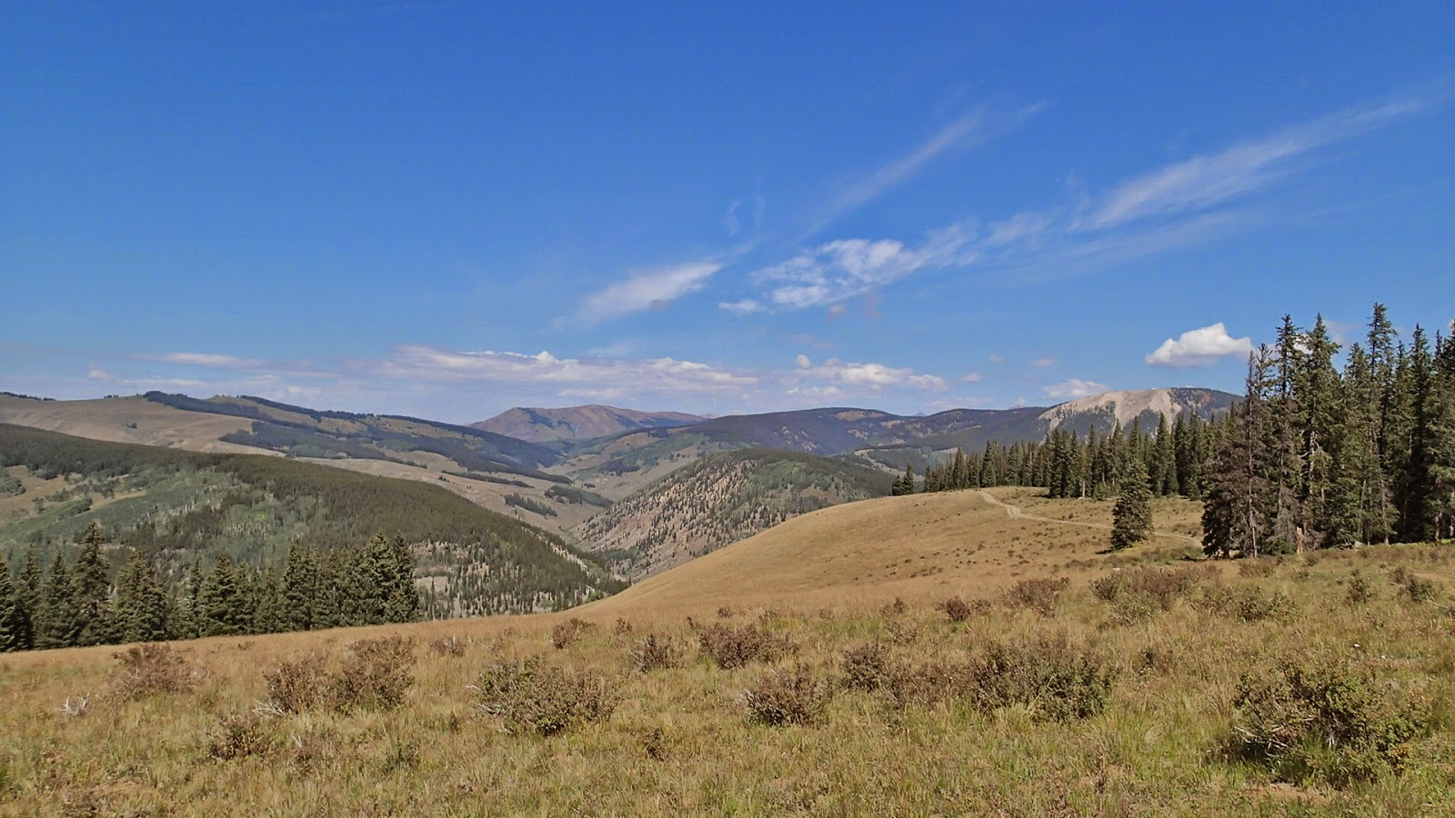
Gentle climb up towards the intersection with Doctor Park Trail.


Looking back from whence I came at the intersection of Doctor Park Bonus and Doctor Park Trails. This is also the sight of the cow pie incident.


Doctor Park Trail: the descent begins here. The upper part is steep, and fairly technical with rocks and small ledges. Lower your seat post.


After the upper technical section of trail ends you'll enter an aspen grove and descend through about 2 miles of smooth, buff, mountain biking nirvana.


Nirvana ends with a slight climb, entering a burned section of pine forest before the final, technical descent to North Bank Campground. From there it was a short ride back to the car wrapping up a perfect ride.

Hartman Rocks


Hartman Rocks is a trail system offering 40+ miles of dirt road and trail access just outside the city limits of Gunnison. The system reminds me a lot of Dupont State Forest, minus the trees, in that the trails are mostly flowing, well marked, and loads of options requiring multiple stops to pull out the map. I'm sure a local could string the trails together better than I did, but its fairly simple to look at the topography on the map and pick a good route. Tech sections on the trails I rode were short, and would be doable with practice and knowing the lines. I did stay off the double black diamond trails, so I can't speak to how much tech is actually available for more advanced riders.


I parked at what I assume was the main parking area about 3 mile outside of Gunnison, which you can see in the background. The ride starts with a climb up onto the plateau from where the scenery and country side opens up. I rode Jack's Trail up to the top, easy climbing, smooth surface, with switchbacks to lessen the grade.


Once on top of the plateau this is what you see. Miles of open country and sagebrush. The scenery isn't as monotonous as it seems from this picture as you have views of the surrounding mountains, and the trails wind in and out of gulches, ravines, and rocky knobs. The trails on the plateau are shared with motor cycles who created the trail system. This leads to smooth berms and whoops that make for extremely fun riding. The aptly named Luge Trail, which I did not photograph, is the perfectly encapsulates this type of riding.


From the Luge Trail I turned up and ascended the first part of Josie's Trail which has a few good rock features before dropping into a ravine for about a mile. The descent is not technical, but is loose and off camber at times.
More rocks on Josie's Trail


From Josie's I climbed back up to the ridge on Buddy Bear Trail, no photos, which gently ascends for a little over a mile to the intersection of Sea of Sage, Broken Shovel, and Rocky Ridge. Sea of Sage continues the gentle ascent and is aptly named as the sage and rolling nature of the surrounding land resemble ocean swells. Sea of Sage joins with Lost Dog and Broken Shovel to form Evan's Loop, a 2.5 mile easy beginner type loops with no obstacles.

View of the surrounding mountains from the start of Broken Shovel


From Broken shovel I jumped on Skyline trail which would be the connector for the western and eastern portion of my ride. Skyline ascends to a small rocky outcrop with a little bit of tech and descends both directions from this outcrop. Skyline rides very well both directions making it a good link trail.


From skyline I rode out Back In and Outback Trails, with outback being the most technical trail of the day. Above is a section of Outback as it becomes more rocky.


Outback trail feeds into Enchanted Forest which is in the heavily wooded ravine to the left. This is the only time you'll be in tree cover the entire ride as the trail descends through a hidden Aspen grove with neat rock features. Sadly my pictures from within the ravine did not turn out too well. From Enchanted forest I turned left and rode out Dave and Moe's trail followed by a 1.5 mile climb on a dirt road back to the intersection with Skyline to Broken Shovel to complete Evan's Loop and out Rocky Ridge Trail. Rocky Ridge starts with a climb and is very technical in spots...
Almost to the summit on Rocky Ridge looking back along the trail as it climbs


...before it smooths out for the descent to Beck's Trail which begins at the rocks in the center foreground.

Sweeping turn on Rocky Ridge descent.


Approaching Beck's Trail, and the final quick descent back to the car. Word of note here: I took Notch Trail over the last lip of rocks and followed a no name trail back to the car. A better option would've been a descent of Jack's Trail or Collarbone.


Friday, August 22, 2014

Monarch Crest, Silver Creek, and Rainbow Trails


The first of the "bucket list" rides in Colorado, the Monarch Crest stretches for almost 11 miles from Monarch Pass to Marshall Pass where you have multiple options for lengthening or shortening your ride. The photographs in this post were taken over the course of two rides as the weather did not cooperate for pictures from the crest on the first ride, and turned to rain after Marshall pass on the second ride. On the first ride I completed the full Monarch Crest ride described as an IMBA Epic which is a full 34 mile ride starting at Monarch Pass including the Crest itself, Silver Creek, and Rainbow trails. On my second ride I shortened the total mileage by about 7 miles dropping down Starvation Creek Trail from Marshall Pass. I actually prefer the descent of Starvation Creek to Silver Creek as it is more scenic as it twists through Aspen and Spruce groves along narrow bench cut side hill trail along the creek. Starvation is less technical than Silver, but requires one hike a bike through a scree field about midway down the trail. Below is a picture typical of Starvation Creek Trail: loamy, narrow single track winding through the Aspens.


The remainder of this post will focus on the typical Crest/Silver/Rainbow route starting with the awesome scenery from the Crest as it climbs away from Monarch Pass. The first 2 miles are fairly steadily uphill until you reach the open ridge which will undulate along the mountain top for the next few miles. The trail itself is only moderately technical with the trail bed being grainy, fast drying, and slightly sandy giving great traction. The trail is a bit rooty in spots when it dives into Spruce groves, but again a fit beginner mountain biker could ride this section of trail without much difficulty. In the images below I've tried to capture both the awe inspiring scenery, and the nature of the trail that allows one access to this special place.


If you enlarge the image you can see the trail as it continues from the left, along the ridge in the foreground, all the way to where it exits the picture to the right.

Nearing the final descent to Marshall Pass.
The following images are of the Continental Divide, Silver Creek, and Rainbow Trails two days prior to the above images. On this day the entire section of the Monarch Crest from Monarch Pass to Marshall Pass was covered in a low cloud, with visibility of about 100-150' at the highest points of the trail. Upon dropping below the cloud cover at Marshall Pass the day became beautiful allowing good shots of the mountains and trails.

The view just prior to dropping onto Silver Creek Trail


Above is the only picture I took of Silver Creek Trail. Don't let the appearance fool you, this is one of the few smooth sections of trail. Silver Creek descends steeply from the Continental Divide Trail to the junction with Rainbow Trail. Along most of its course it is very rocky with numerous scree fields to cross.


Unlike Silver Creek Rainbow trail is fairly smooth, flowing, and non-technical along most of its course. It does however feature an elevation gain of about 1,300' along its 8 miles from the junction with Silver Creek. Most climbs are short, steep, and non-technical, but you will have a couple of sustained, rocky climbs towards then end of the trail.


 Views such as this are you reward for the short, steep climbs on Rainbow Trail. Along with smooth, sinuous, and flowing single track.


Above is the start of the final descent on Rainbow Trail back to Hwy 285. This portion of trail, while not technical, is very steep. Your brakes will be hot by the time you reach the intersection with the road. From the Hwy it is about 4.5 miles of downhill coasting back to your car.